“Adventure = Adversity Recounted at Leisure”
Usually when I do group rides it is with my STN friends, but this time I’d do some northern exploration with some guys from ADV. These guys come across as pretty hardcore dirt riders on the website and I found that they’re no different in real life. Here’s my weekend attempt at following them across some of lower BC’s finest roads.
June 30 ~ July 3, 2007
Total Miles: 1,080 miles, 4 days
Seattle, WA to most of lower BC
Map Link
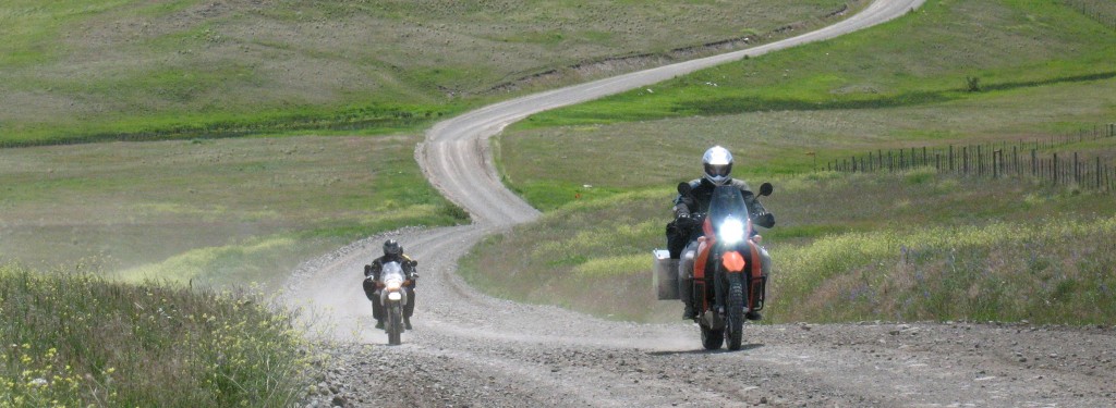
I chose not to take Friday off for the first day of the ADV BC ride and it turns out that was a good choice: the riders who did head east that day ran into rain – a lot of rain! Instead I was comfy inside my office making money, one of the few times I didn’t mind not being on my bike. But Saturday morning I was ready to depart for the great foray into the unknown back country of British Columbia! I rode to Monroe where the plan was to meet up with Chris (from my recent Custer trip), Ryan (from the 03 Custer trip) and Michael (an ex co-worker). Michael couldn’t make it so the three of us altered the initial plan and routed our bikes up to Rockport and over the North Cascades Highway. It was beautiful as always and we were blessed with little traffic and lots of sun. However, recent activities along this route made us all extremely leery of increased police presence and we kept the speeds down. I found this to be entirely unacceptable and confess that it really did bring down the “fun factor” to an almost unbearable degree. We lunched in Winthrop where Ryan then asked about the next dirt section that I had in mind. I wasn’t sure about this road and how easy it would be to follow it through the mountains behind Winthrop and into Conconully but Ryan was excited to try it and I suggested that he take the lead.
It turned out to be a stellar choice. The Conconully area was hit hard by wildfires last summer and the devastation was incredible. Just when I thought that I had ridden through the burned area I’d round the bend and see acres and acres of charred timber. The track itself was in excellent condition, being a wide one-lane gravel forest service road with short patches of pavement. I think that the pictures speak for themselves.

I think this sign should be more frequently posted

Just north of Winthrop

Early signs of last year’s forest fire

Here comes Chris!

A river runs through it

Serious burn

Massive amounts of burned forests

A view to the west

More fire

Up close – not much made it through

The road as it cuts through the burn area

Here comes Ryan!
Eventually we stopped gaining elevation and found ourselves looking east from Mt Baldy. The forest fire was still evident but quickly passed into the background as lush and green forests gathered up against the road. The way down was fast and fun, eventually running into decent pavement with the occasional sections of gravel – usually in the corners where it causes the most fun.

The view to the east from Mt Baldy

Summer flowers

The road to Conconully

Lake just past Conconully
After a brief break in Conconully we kept going north, this time towards Loomis and eventually the Nighthawk border crossing into Canada. The road started out tight and twisty, tucked among tall trees and a flowing river. But eventually the valley opened up and so did the road. As I told Ryan, “It’s a fast dirt road”.

Ryan

Heading for Loomis

Lake south of Loomis
The border crossing was the easiest I had ever experienced. None of us even had to get out our ID – he just asked where we were going and how long we’d be there and then wished us a nice day. After asking for (and receiving) a new stamp in my passport we headed for the Smilkameen Valley and one of the most beautiful rivers in lower BC. The road here (#3) is fast and easy, giving us quick passage to our next dirt section: the Hedley-Nickleplate Rd. This would be a road not taken by the ADV crew and I felt pretty slick in sneaking it into our itinerary.
It’s a torturous dirt track up the side of a mountain that doesn’t appear to exist for any other reason then my own enjoyment. Well, that and the gold mine tour company that runs shuttle buses up there a few times a day. Steadily rising above the valley, each turn gave me a slightly better view than the last one until finally I reached the perfect spot for a view of the road before it dove back into the mountains and away from the valley.

Smilkameen Valley near Hedley, BC

Ryan coming up the mountain

Halfway (?) up!

Still not to the top, but the best view

Rapid elevation gain
From here the road was very non-technical with wide, well-groomed gravel and open stretches that led passed the Nickelplate Gold Mine. Much to my surprise, it also led by this odd little cemetery. Each small picket section contained no markers or headstones but instead a number of trees grew within the borders, presumably because of the protection from wandering herbivores.

Random cemetery

No headstones, just trees
It was a surprise to us that just after this section we came upon the Apex Ski resort, and we figured that we were at least another 40 miles from civilization. From Apex the road became fast and paved and very much fun. It dropped down rapidly at first, then gently let us down into the Okanagan valley in Penticton. From Penticton it was a fast ride up 97 to Kelowna where arrangements had been made to camp out in the vineyards of Summerhill Pyramid Winery.

Setting up the tent in the vineyard

Ryan enjoying a cold one

Not a bad place to be
The next morning Ryan took off for breakfast with some other riders while Chris and I packed up the tent and supplies. I think that he and I were the last ones out of the vineyard and headed directly for Westside Rd, a wonderfully wild and rural road that follows Okanagan Lake all the way to its northern terminus. It’s a much better choice than 97 that blasts up the east side, that’s for sure.
From then end of Westside Rd we followed 97 to the turn off to Douglas Lake Road. Chris and I had done this road two weeks ago after a hard rain and I was looking forward to riding it again with the better weather. But while the weather had improved, the road had not. It had just been graded (and in some cases was still being graded) which left us with a loose and unsettled surface.

Near Falkland, BC

Starting out on Douglas Lake Road

A young river
This time through I took a detour at Douglas Lake and led Chris and I on a little side road that I find enchanting. I love the little forested glades it dips into, the hard packed dirt surface, the narrowness of the road itself – and the desolation. It wasn’t desolate for long, however, as three bikes pulled up while we had stopped for photos. Imagine my surprise to see Ryan in the group! He, Mike and Suzanne joined us for the rest of the day.

South of Douglas Lake

Chris on the easy roads

Wheeeee!

A variety of settings

Some nice views

And interesting clouds

Waiting for the others

Highway 12 out of Lytton
A quick regroup in Lillooet and we were on the road to Gold Bridge. Ryan’s GPS had the route and maps on it so we let him lead us out of town. The road started out by reminding me of The Hill on the way to Bella Coola. It was carved into the hillside with a deep canyon on one side and high rock walls on the other. A considerable amount of traffic was coming out so the blind corners were to be taken with care.
Eventually the dirt gave way to pavement and I was glad for it, as it gave me more time to fully appreciate the views around me. God, what beautiful country!

Road to Gold Bridge just out of Lillooet

Heading south towards Gold Bridge

Following the river

Looking back

Overhanging rocks

How am I supposed to pay attention with scenery like this?

Scenery

This sign looks a little out of place

Falling rocks

Paved section to Gold Bridge

More scenery
This road just went on for miles. I don’t know how many miles, but a lot of them. Heck it was 47 kilometers just from Lillooet to the dam and that wasn’t even a quarter of the way there! The road following Carpenter Lake was fast and interesting. The five of us took turns leap frogging for photos and generally wicking it up on the good roads. We pulled into Gold Bridge fairly late and were surprised to see a crowd of bikes at the Gold Bridge Hotel. I say “surprised” because we were led to believe that the group was going to skip Gold Bridge and ride directly to Whistler that night. I’m glad that we decided to do the original route.

Setting sun over Carpenter Lake

More views

Back to gravel roads

Carpenter Lake

Bikes in Gold Bridge

Our own private picnic table
The next morning Chris and I were again the last ones to pack up and hit the road. “The road” was 50 miles of mostly fast and good gravel with equally distracting views. Single lane bridges abounded, as well as waterfalls and an infrequent vehicle. At the high point, about 4,500′, I was surprised to come across snow pack still melting from the roadside. It didn’t last long and I was soon careening downward, racing to catch up with Chris. I had stopped for a couple of shots and knew that it wouldn’t take long to catch up to him. What I wasn’t counting on, however, was the first of a series of 20mph switchbacks. I came into the first one about 40mph. Somehow, with both wheels sliding towards the edge of the road and the curve not giving up, I slowed the bike down considerably and began the turn. The rear end slid some more while I kept the front wheel pointing at where I wanted to go. I got closer to the edge of the road but managed to keep the bike upright and on course. Whew! Of course Chris didn’t recall this corner because he had already been going 20mph.

Starting out for Pemberton

Man-made lake outside of Gold Bridge

Heading into the mountains

Distracting views

Typical one lane bridge

A surprise view from the bridge

Good, fast roads with plenty to look at


Chris and I wondered what was wrong with the road

Near the highest point of the road

“Road Closed in Winter” – I can see why!

Coming down into Pemberton
After an eternity of downhill twists and turns we reached the pavement outside of Pemberton. A leisurely stop there for a fresh deli-made lunch and then we headed off to the next – and final – section of dirt. If I had known how hard it would be I honestly would not have done it. Sure, maybe some day on the KLR, but not on the GS and not with Chris, who had minimal dirt experience and was also on a heavy bike. But we didn’t know and we headed south in an oblivious haze of joy.
It started out well enough: a quick jaunt up the fast and twisty pavement near Lillooet Lake, only to realize that the turn for Lillooet Lodge was actually the road we wanted. Back down the lovely twisted pavement and onto the dirt road. Again, a surprising amount of traffic greeted us as we rode south along the lake shore.
A poorly marked bridge matched up with my map and GPS coordinates. It was time to move over to the west side of the lake. The road narrowed, the traffic died down and all was well. Eventually we reached the north end of Harrison Lake. At first I thought that I had missed a turn as we passed a couple of buildings, some looking vaguely like houses, and then entered a logging yard. Surely this couldn’t be the road?
But it was, and at the other end of the logging yard was the fateful sign that the next section of road was “4 x 4 Only”. The road rose ominously up away from the lake and under the power lines. Chris and I took this time to relax by the cool breeze of the lake and prepare for the next section. Little did we know that nothing could have prepared us for it

Lillooet Lake

“Watch for Logging Trucks” – I think I will

After crossing to the west side of the lake

Chris tries another fix for his chain guard


My bike, all ready to go


This is the road

Floating shack

The start of the 4×4 road
It is extremely difficult to accurately capture elevation changes with the camera, and even more difficult to convey the complexity of the road surface. I’ve done what I could, but if you magnify what you see by about 10, you’ll have a closer understanding of the conditions we were riding in.
First off was a quick repair to Chris’s bike. His chain guard kept coming loose. Zip ties were no match and even a few loops of baling wire snapped quickly. Finally we resorted to cannibalizing my cargo net for one of the hooks and using that. It worked.
A couple of lighter dual sports coming the other way said that we were about 1 1/2 – 2 hours behind the rest of the crew. I didn’t much care, as I didn’t expect to see them that day anyway. But the guys mentioned that the road had a couple of “rough spots” ahead. Talk about a phrase that was open to interpretation! Chris and forged on, with me wondering at every little bump and rock if that was the “rough spot”. How naive of me.
The “rough spots” were stretched out over a 10 or 15 mile section of road. Steep uphills with lots of loose rocks, steep downhills with lots of loose rocks, river crossings on corners; it was all there. The BMW was not the bike I wanted to be on for this. The KLR would have been infinitely more fun, but since I was stuck with the GS I made the best of it. I used what little dirt experience I had accumulated and put it to the test. I shared what I could with Chris. Together the two of us picked up bikes (mine twice, his four times) and pushed his bike up inclines when the tires just couldn’t get a bite into the rocks. It took us an hour to get through here.

Lots of elevation changes

Despite what you see, a surprising amount of traffic kept me on my toes

More blind corners

Downhill isn’t much fun

Loose rocks + downhill + heavy bike = a lot of work

Trying to show the elevation change

Chris’s first water crossing!

Deep loose rocks + corner + uphill = even more work

Coming down a little too fast
The heavy bikes worked against us and the street-biased tires didn’t help either. We looked at each other and just rolled our eyes. What would be the point of turning back now? So we soldiered on and eventually got through the “rough spots” and back to a more tolerable road surface. Markers along the way counted down the few remaining kilometers, starting at 50. Those were the longest 50 kilometers of the day. I was excited when I spotted “1 KM” but then was crushed when the next few miles were just a continuation of the same dirt road. Eventually we reached pavement and kept on riding until we reached the town of Mission, BC. It was 8:30pm. We had been on the road for twelve hours, covering just under 200 miles and were both exhausted.
Chris planned to blow off work the next day and just stay in BC for the night. I thought that sounded like a splendid plan and did the same. We got a room, I grabbed a quick shower and then we went and found a steak dinner. I slept very well that night and was able to get us up and on the road by 7:30am. After a invigorating ride down 9 I went directly to work, arriving at 10:30 and surprising them all. Apparently no one had gotten my message that I would be in late. I sat at my desk for five hours and then went home, napping for an unheard of 3 hours. Canada had beaten me this time.