Random Ride to the South
It was a holiday weekend and it was almost over. Saturday and Sunday had already slipped by and now it was Monday. Monday, the day before I would have to go back to work. So I made a plan to hit some previously un-ridden (by me) roads to the south. I had been north, and west, and east – now it was time for the last of the cardinal directions. With a vague plan in my mind, I left the apartment shortly after I would have normally left for work.
January 20, 2009
Total Miles: 311 miles
Mountain View, CA and points south
Map Link
The goal was to take as many side roads south to Gilroy and then Hollister before sweeping west to the ocean and returning north. The first thing to do was to get out of town, following the Interstate for 20 miles or so before I came to my first set of back roads. Leaving the highway I bumbled around on some heavily traveled arterials before finally coming to some small and empty roads. I had been on this one before (Hicks Rd) and I knew that it was a fun one, so I kept on following it. Only when I reached the other end of the road did I realize that it took me nowhere where I wanted to go. I was now almost back to where I started and on the wrong side of my route. Eh, what’s a little on-the-fly decision making? I checked my map and made some adjustments. Now I was heading south on 17 – a wide but always busy highway that goes over the mountains to the coast. But I wouldn’t be on here long – I was getting off at Summit Rd. and heading southeast.
Summit Road turns into Highland Road after a brief, confusing couple of intersections. I wasn’t the only one confused, as there were a couple of other vehicles making the same u-turns as I was. Traffic was surprisingly heavy for such a poorly maintained road, so I stuck to my half of the one and a half lanes alloted me. Eagle Canyon Rd almost seamlessly blended in with Highland Rd, although I confess that the road signs weren’t very clear to me. But I guessed, and guessed correctly. There was a lot of charred tree trunks and dry, brittle leaves along here, giving evidence that a low-burning forest fire had come through recently. It was just one more aroma to add to the day: charred wood, fresh pine, newly turned soil, damp earth, cow paddies and salty ocean air.

View from Highland Rd

They appear to be having a slide problem

Another slide problem

Great vegetation in this area

Warm sunshine on Highland Rd

Highland Road

Recent evidence of fire

Eagle Canyon Rd cuts along the hillside
Coming down out of Eagle Canyon left me in the hinterlands of Wastonville. I’ve heard un-kind things about Watsonville, mostly about how unsafe it is and your stuff will get stolen if you don’t keep an eye on it. But as I rolled through the well-maintained downtown, I felt a keen sense of “Mexico!” I couldn’t put my finger on it, but the Hispanic population and the Mexican taquerias probably had a lot to do with it. After rolling my way out of town and on towards Gilroy, I came to the determination that I would find myself a taco truck. Not that I was hungry in the slightest, but I always get the best burritos from those shiny metal rolling taco trucks sitting parking lots and alongside the road, and today I wanted one. Not an hour passed before I came across the first one, parked at a pull-off near the junction of Hwy 129 and 101. I pulled in sharply, between a couple of semis and some dusty pick-up trucks already in the lot. I wish that I had more Spanish lessons under my belt, but I ordered my burrito pollo con arose and ate it at one of the chained up picnic tables under the trees. Mmmm. Small, but tasty.

Orchard near Watsonville

Burrito!!!
Now it was time to head south, my original goal. It was already well passed noon and I hadn’t gotten very far. I hit Hwy 25, which started out as dead-straight, running through farm and ranch lands on either side. There was “Old Airline Rd’ alongside 25 and I realized too late that it would have been much more interesting, even if it didn’t go anywhere I wasn’t going anyway. A few miles later I passed a sign warning against long trucks taking this route, as it got curvier up ahead. Good news! I was just getting into the rhythm of the smooth, dry roads and the warm air passing over me when I spotted a road sign out of the corner of my eye: La Gloria Rd. Wait! That was the road that I was looking for!
I finally found a straight enough portion of road the turn around on and pulled over to one side. I was then vaguely bewildered by the bits of sport-bike plastic I saw littered on the other side of the fence – a wreck on the straightest portion of road? After making my u-turn I backtracked to the turn off. I stopped the bike, looking on in amusement: I felt more like I was about to enter a farmer’s field then cross the mountains on a public road. The gate was open, but obviously well-used. The lane was narrow.and the way was hemmed in by thin wire fencing. This was going to be good.

Fields along Hwy 25

Old Airline Rd runs alongside Hwy 25

Abandoned house on Hwy 25

Barn near the abandoned house

Looking down Hwy 25

Plastic bits, left behind from an unfortunate rider
La Gloria Road is a 13 mile slice of dirt heaven. It is in no way technical, with the surface wide and evenly groomed. No sand, no rocks, no real challenge. But just the joy of being where few others bothered to go was peace to my soul. I saw the tracks of a bike that had gone before me, but it could have been an hour ago or a day ago, it didn’t really matter. What I enjoyed was the solitude and the lack of “civilization”. There were signs on either side of the road, warning me that the land was private, but I wasn’t interested in going on the land. I was happy enough to be allowed to ride through it.
The road started out in thick trees, following a little creek. I should have stopped for a photo or two, but I was too distracted by the pleasure of riding. Eventually the landscape changed and the novelty of riding on the dirt wasn’t quite as sharp and I stopped to capture the moment. The trees had given way to open fields, dotted with cows and well, cows. I crested the range I was crossing and now began a long descent. This would have been more fun going up, but it wasn’t too bad this direction. The road was tight and it gave me a grand view of the valley below. I could almost see Hwy 101 running the length of the valley, but a slight haze in the air kept any details from being revealed.

The eastern entrance to La Gloria Rd

Going deep into the hills

Bucolic views along the way

Easy dirt roads clear my mind

Coming towards the descent

Looking down into the valley

A pick up truck makes its way down, a plume of dust behind it
At the bottom of La Gloria Rd (now just called “Gloria Rd” I was spit out onto Hwy 101. I thought that I should get some gas and popped north for an exit to the town of Gonzales before turning around to go south and find Carmel Valley Rd. It shouldn’t be too hard, as I could see on my large-scale map that it met up with the highway in Greenfield. But I rode through Greenfield and never once saw a sign for Carmel Valley Rd. I thought this odd, as this road was the most direct way to get to the ocean, and I thought for sure that it would have been well-marked. I took a closer look at my map, re-estimated my route and went back up 101.I found the right road (Elm Ave, oddly enough) and went west.
Carmel Valley Rd has a bit of an identity crisis, as it goes through quite a few name changes. Elm Ave, Arroyo Seca, Jamesburg, East Carmel Valley Rd, West Carmel Valley road and finally, Carmel Valley Rd. It also straddles the San Andreas Fault, so there is plenty of eye candy to keep me busy as I weave my way along the valley.

Bridge just outside of Greenfield on Arroyo Seca

Families enjoying the river

San Andreas Fault escarpments


Rolling along the Carmel Valley

Furry trees!

Thankfully, the road was dry
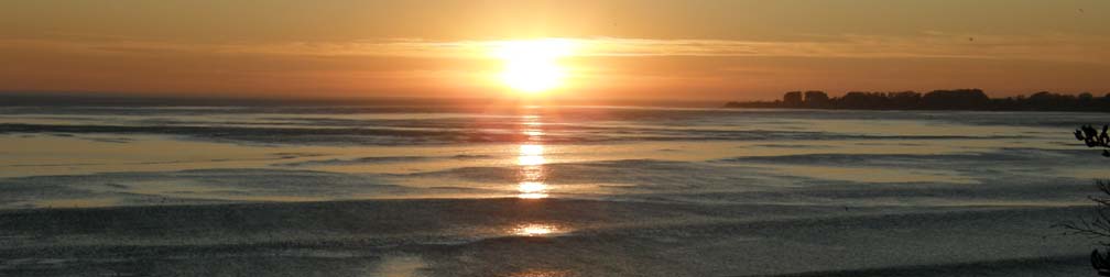
After a splendid ride through the valley I ended up in Carmel and then, a little further on, in Camel-By-The-Sea. It was time to get head home, which would be easy enough. I turned north on Hwy 1 and fought a little bit of traffic before things opened up and I rolled by such famous names as Pebble Beach, Monterrey and Santa Cruz. But before I reached Santa Cruz, I reached the small town of Seacliff. There wasn’t anything particularly interesting about this town other than its convenient location along the cliffs and the timing of the falling sun. I wanted to watch the sunset.
I parked my bike at the top of the bluff and enjoyed the scenery as I waited for the light to turn to a golden glow across the waves. While I waited, I noticed an odd pairing of what appeared to be a beached ship and a jetty. I found out later that this ship was put there on purpose to serve as an amusement park of sorts. You can read more about the Seacliff State Beach here. While I waited, a sundog appeared along the horizon, but my camera was no match for it. Eventually the sea swallowed up the light and it was time to get home. I had to cross back over Hwy 17, made completely miserable by people who don’t seem to understand the concept of driving and finally arrived at the apartment just a little bit later than I would have if I had been at work. It was a great way to spend my holiday.

Tracks on the beach near Moss Landing

South of Seacliff State Park

Beached ship at Seacliff SP

Sunset at Seacliff

Enjoying the refection of the sunset on the gently rolling waves